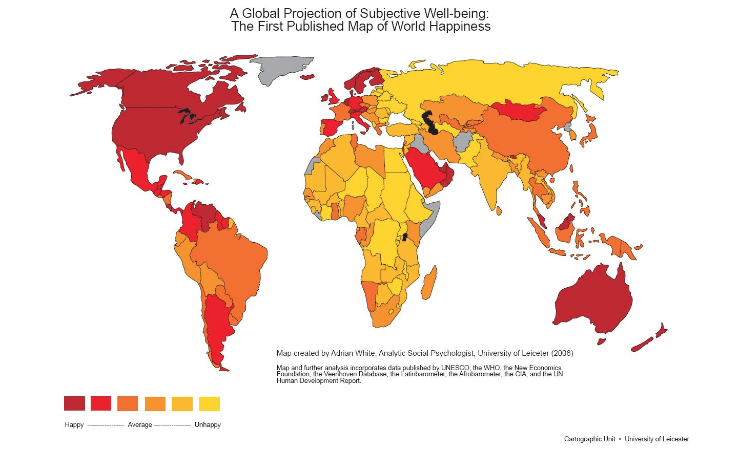
 Image credit: http://www.mindpowernews.com/world_map_of_happiness_lrg.jpg
http://www.npoki.org/gis-conference-trainings/
Image credit: http://www.mindpowernews.com/world_map_of_happiness_lrg.jpg
http://www.npoki.org/gis-conference-trainings/

Have you considered the option of getting trained in GIS. If you are an officer who wants to use GIS in your department, or a student who wants to learn GIS, there are 3 level courses being offered that cover everything from basics to map making, spatial analysis, imagery interpretation and analysis. The course will be certified and the duration is 1 week for each level and is being conducted at the premises of Deccan Consultants in Bhopal.
For more details, on dates and visits visit deccanconsultants.com
or write to geospatialtrends@gmail.com, dcbhopal@gmail.com
or call
+919826224441
+919893295255
Event Calendar of GIS Conferences – GeoInformatics
Here are a list of conferences and workshops for 2015, according to the calendar found on GeoInformatics, a leading magazine on GIS
2015
May
04-08 May ASPRS 2015 Annual Conference
Tampa Bay Marriott Waterside Hotel, Tampa, FL, U.S.A.
Internet: www.asprs.org
05-08 May RIEGL LIDAR 2015 International User Conference
Hong Kong and Guangzhou, China
Internet: www.riegl.com
11-15 May 36th International Symposium on Remote Sensing of Environment – ISRSE 2015
Berlin Congress Center, Berlin, Germany
Internet: www.isrse36.org/programme
14 May GeoDATA Seminar
Birmingham, U.K.
Internet: www.geoinformationgroup.co.uk/training/geoDATA
17-21 May FIG Working Week 2015
Congress Centre Sofia, Sofia, Bulgaria
Internet: www.fig.net/fig2015
19-20 May WVGA User Conference 2015
Literaturhaus, Munich, Germany
Internet: http://euspaceimaging.us5.list-manage.com/subscribe?u=afbe993ce225d71274b8f371b&id=e6b3f18f8e
21-22 May EUROGEO Conference 2015
Ankara, Turkey
Internet: www.eurogeography.eu/2015-meeting-and-conference
24-29 May INSPIRE and Geospatial World Forum 2015 Conference
Lisbon, Portugal
Internet: www.geospatialworldforum.org
27-28 May GEO Business 2015
Business Design Centre, London, U.K.
E-mail: info@GeoBusinessShow.com
Internet: www.GeoBusinessShow.com
June
01-04 June HxGN LIVE 2015
Las Vegas, NV, U.S.A.
Internet: http://hxgnlive.com/las.htm
01-06 June 28th International Geodetic Student Meeting (IGSM)
Espoo, Finland
Internet: www.igsm.fi
02 June Internet of Things Event
High Tech Campus, Eindhoven, The Netherlands
Internet: http://iotevent.eu
04-06 June 2nd International Course on Geotechnical and Structural Monitoring
Poppi, Tuscany, Italy
Internet: www.geotechnicalmonitoring.com/en/home-2
06-08 June State of the Map 2015
New York, U.S.A.
Internet: http://stateofthemap.us/
08-09 June UAVveek 2015
Siegen, Germany
Internet: www.microdrones.com/en/company/public-relations/uavveek
09 June GeoDATA Seminar
Brussels, Belgium
Internet: www.geoinformationgroup.co.uk/training/geoDATA
09-12 June Optech 2015 – Imaging and Lidar Solutions Conference
Toronto, Canada
Internet: www.optech.com/ilsc2015
09-12 June Spatial Statistics: Emerging Patterns
Avignon, France
Internet: www.spatialstatisticsconference.com
11 June GeoDATA Seminar
Amsterdam, The Netherlands
Internet: www.geoinformationgroup.co.uk/training/geoDATA
16-25 June 15th International Multidisciplinary Scientific GeoConference & EXPO SGEM2015
Flamingo Grand Congress Center, Albena Resort & SPA, Bulgaria
E-mail: sgem@sgem.org
Internet: www.sgem.org
21-27 June The Vespucci Institutes 2015 – Spatial Ontologies fo e-Science
Vespucci Institute,Bar Harbor, ME, U.S.A.
Internet: http://vespucci.org/programme#week1
29 June-03 July The Vespucci Institutes 2015 – Advancing Geographic Information Science: The Past and Next Twenty Years
Vespucci Institute, Bar Harbor, ME, U.S.A.
Internet: http://giscienceconferences.org/vespucci2015week2
July
05-11 July ISPRS Innsbruck Summer School of Alpine Research 2015: Close Range Sensing Techniques in Alpine Terrain
Obergurgl, Austria
Internet: www.uibk.ac.at/geographie/summerschool
07-10 July GI_Forum 2015 – Geospatial Minds for Society
Salzburg, Austria
E-mail: office@gi-forum.org
Internet: www.gi-forum.org
14-17 July FOSS4G-Europe 2015
Politecnico di Milano, Como, Italy
Internet: http://europe.foss4g.org/2015/
20-24 July Esri User Conference 2015
San Diego Convention Center, San Diego, CA, U.S.A.
Internet: www.esri.com/events/user-conference
21-23 July International Workshop on Image and Data Fusion (iwidf2015)
Kona, Hawaii, U.S.A.
Internet: iwidf2015.casm.ac.cn
28-31 July 13th South East Asian Survey Congress (SEASC 2015)
Marina Bay Sands, Singapore
Internet: www.seasc2015.org.sg
Augustus
30 August – 02 September UAV-g 2015 International Conference on Unmanned Aerial Vehicles in Geomatics
York University, Toronto, ON, Canada
Internet: www.uav-g-2015.ca
September
06-09 September 2nd Annual GIS Forum MENA
Abu Dhabi, United Arab Emirates
Internet: www.gisforummena.com
07-11 September 55th Photogrammetric Week
University of Stuttgart, Stuttgart, Germany
Internet: www.ifp.uni-stuttgart.de/phowo/index.en.html
09-11 September InterDrone
The Rio Las Vegas, Las Vegas, NV, U.S.A.
Internet: www.interdrone.com
15-17 September INTERGEO 2015
Stuttgart, Germany
Internet: www.intergeo.de
21-24 September SPIE Remote Sensing 2015
Centre de Congrès Pierre Baudis, Toulouse, France
Internet: http://spie.org/spieremotesensing
28 September – 03 October ISPRS GEOSPATIAL WEEK 2015
La Grande Motte, France
Internet: www.isprs-geospatialweek2015.org
October
05-07 October Commercial UAV Expo
Caesars Palace, Las Vegas, NV, U.S.A.
E-mail: lmurray@divcom.com
Internet: www.expouav.com
05-09 October 9th Symposium of the International Society for Digital Earth (ISDE)
Halifax, Nova Scotia, Canada
Internet: http://digitalearth2015.ca/
11-13 October Geodesign Summit Europe
Mozarteum University Salzburg, Salzburg, Austria
Internet: http://geodesignsummit.com/europe/
12-16 October SELPER 2015
Ciudad Juárez, Chihuahua, Mexico
Internet: www.uacj.mx/SC/Paginas/SELPER-M%C3%A9xico-UACJ-2015.aspx
14-16 October Esri European User Conference
Salzburg, Austria
Internet: www.esri.com/events/euc
26-29 October 15th International Scientific and Technical Conference “From imagery to map: digital photogrammetric technologies”
Yucatan, Mexico
Internet: www.racurs.ru
28-30 October Joint International Geoinformation Conference 2015
Kuala Lumpur, Malaysia
Internet: www.geoinfo.utm.my/jointgeoinfo2015/index.html
November
05 November GeoDATA Seminar
Belfast, U.K.
Internet: www.geoinformationgroup.co.uk/training/geoDATA
12 November GeoDATA Seminar
Edinburgh, U.K.
Internet: www.geoinformationgroup.co.uk/training/geoDATA
16-19 November Pacific Islands GIS\RS User Conference 2015 ‘Bridging Information Gaps by Creating Smarter Maps’
Suva, Fiji
Internet: http://picgisrs.appspot.com
18-20 November HxGN LIVE 2015
Hong Kong, Hong Kong
Internet: http://hxgnlive.com/hkg.htm
December
03 December GeoDATA Seminar
London, U.K.
Internet: www.geoinformationgroup.co.uk/training/geoDATA
09-11 December 9th International Symposium on Mobile Mapping Technology (MMT2015)
Sydney, Australia
Internet: www.mmt2015.org
09-11 December SPATIAL the un-conference – Spatial Information for Human Health
University of California, Santa Barbara, CA, U.S.A.
Internet: http://spatial.ucsb.edu/spatial2015
10-11 December GeoBIM
Amsterdam, The Netherlands
Internet: www.geo-bim.org/Europe
2016
April
18-22 April ASPRS 2016 Annual Conference
Grand Sierra Hotel, Reno, NV, U.S.A.
Internet: www.asprs.org
June
27-29 June International Workshop on Risk Information Management, Risk Models, and Applications
Berlin, Germany
Internet: http://RIMMA2016.net
October
11-13 October INTERGEO 2016
Hamburg, Germany
Internet: www.intergeo.de
2017
October
10-12 October INTERGEO 2017
Berlin, Germany
Internet: www.intergeo.de
Owning a GIS Software can be an expensive affair. If you are looking to learn to use a GIS Software, without investing much, here are some softwares that are freely available. However proprietary softwares like arcgis, do have their advantages, these open source softwares can be a good place to begin. Here we have listed some, where you can go to the site and explore
uDIG
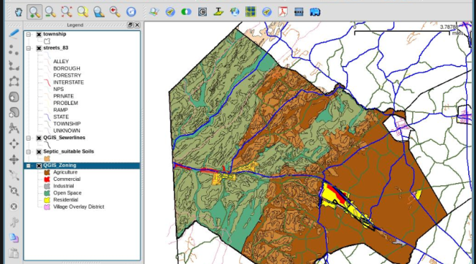
QGIS http://www.qgis.org/en/site/
OpenJump http://www.openjump.org/
gvSIG http://www.gvsig.com/en/home
TerraView http://www.dpi.inpe.br/terraview_eng/index.php
Kosmo http://www.opengis.es/
WhiteboxGAT http://www.uoguelph.ca/~hydrogeo/Whitebox/index.html
Some good softwares that can be used for remote sensing and image interpretation are
Saga-GIS http://www.saga-gis.org/en/index.html
GRASS http://grass.osgeo.org/
GIS welcomes Cloud Sharing
Building web maps and sharing information on the cloud, has become easier through services like those offered by ESRI. ArcGIS Online is a new way forward in sharing maps, map applications and using this platform to use services from arcgis online, bing map and even ArcGIS Server.
This works through the system of credits, where credits can be purchased and used for using basemaps, data, analysing data, creating mapping and other analysis services.
You can register for a trial on the website https://www.arcgis.com/home/signin.html
Dean M Howell takes an in-depth look at the pros and cons in his article http://geoawesomeness.com/gis-cloud/
Cloud GIS – Pros and Cons
Everything these days seems to be heading to the cloud. You can store your documents, images, contacts, calendars, presentations, articles, accounts, everything in the cloud. So it just seems logical that GIS is also heading that way. Most of the leading GIS vendors have developed Cloud GIS solutions or certainly thinking about it and a growing number of private companies are also dipping their toes in the market. This article has not been written to compare the various solutions on the market, although I may look at doing this in an upcoming article, but just to look at some of the broad advantages and disadvantages of cloud GIS.
Having said that, some of the big players currently include Map2Net, ArcGIS Online, GIS Cloud, MapBox, Mango Map, CartoDB and MapInfo Stratus. I am sure there are many more on the market or about to hit the marketplace, so do you due diligence before jumping into this emerging way of getting your GIS out to the world.
Having said that, some of the big players currently include Map2Net, ArcGIS Online, GIS Cloud, MapBox, Mango Map, CartoDB and MapInfo Stratus. I am sure there are many more on the market or about to hit the marketplace, so do you due diligence before jumping into this emerging way of getting your GIS out to the world.
Advantages for Cloud GIS
- Data Access
- Access can be via any internet connection, anytime, anywhere. I see this as both an advantage and a disadvantage, if you have a good internet connection then it is great but if you do not then it will quickly become a source of frustration for your users.
- Distribution
- If you have a range of remote users then cloud GIS makes the distribution of your data, analysis and systems very simple. No need to send data using DVD or downloading large datasets to update a local server.
- Data Capture
- Having a cloud GIS allows data capture in real or near real time to be displayed directly onto your system. There are also many successful applications of where data has been captured by the general public and verified by users. One such success story is open street maps.
- E-commerce
- The ability to sell your data or online services to a wider audience can open up the income streams for your organisation through cloud GIS.
- IT Management
- The need to have dedicated GIS Administrators will be reduced as you can outsource that to the cloud GIS hosting organisation
Disadvantages for Cloud GIS
- Data Access
- Access can be via any internet connection, anytime, anywhere. I see this as both an advantage and a disadvantage, if you have a good internet connection then it is great but if you do not then it will quickly become a source of frustration for your users.
- Security
- Security is an important aspect of any system and you will need to make yourself sure that the cloud GIS hosts have good security in place so your data is not accessed by users who should not be accessing it.
- Data Volume
- GIS data has always been big, taking up gigabytes on your own server. If you move to a cloud GIS solution then there is both the time to migrate the data to the host server and also for end users to access and download. There is a lot of clever sampling software out there for web-based GIS so the end user may not notice and issues if just viewing but downloads maybe a different issue.
- External Hosting
- This can be a major concern as the cloud GIS hosting organisation may not have your best interests at heart. They are a business after all and in it to make a profit but they will also be striving to provide you with a valuable service so they do not want things to go wrong.
- What sort of back-up and redundancy systems are in place with your cloud GIS host. Make sure that they are not backing up your data during your business hours or if they are that it does not impact on the delivery of your service. Remember that cloud GIS servers can be based anywhere around the globe and what is midnight for them might me 10am for you.
- Is the cloud GIS host offering you a dedicated server, if not who else is sharing it. What sort of load is there system but for.
- Lack of Control
- Another downside of cloud GIS, is the lack of control you may have over the way your data is used, displayed, manipulated and analysed. To add a new function or layer may not be as simple as just loading a new dataset onto the server.
- Data Format
- What formats is the cloud GIS application serving the data out in. Do you need to reformat your data?
There are a lot of advantages and disadvantages to cloud GIS but it looks like it is something that is here to stay and maybe worth looking at as a way to simplifying the needs of your organisation and the needs of your users. Look for a service that meets your needs, your data formats, your end users and the level of control you want.
source: Empowernetwork
About The Author
Dean M Howell – Founder & CEO Of GeoSpatial Connect
I am a cartographer by professional with over 25 years in the GIS / Mapping Industry. GIS has allowed me the opportunity to work around the globe in countries like Singapore, USA, New Zealand, East Timor and throughout Australia. I have a passion for helping people in the industry with their careers and have spent most of the last decade running my own GIS specific recruitment company and websites.
other interesting reads
http://geoawesomeness.com/national-gis-india/
and
GIS has been very instrumental in the fields of disaster management, be it cyclones, the Haiti quake and the more recent earthquake of 7.8 magnitude that rocked Nepal, claiming thousands of lives and damages to property, and national heritages as well.
Many mapping agencies like ESRI, Open Street Maps have helped in identifying regions that have been hit and planning out rescue operations. The International Centre for Integrated Mountain Development (ICIMOD),based in Nepal, has set up a dedicated webpage to provide the latest maps, data and information regarding the earthquake to assist in the relief operations
http://www.esri.com/services/disaster-response/earthquakes/nepal-earthquake-swipe
http://wiki.openstreetmap.org/wiki/2015_Nepal_earthquake
Light Detection and Ranging (LIDAR) is an airborne mapping technique, which uses a laser to measure the distance between the aircraft and the ground.
This technique of surveying has gained great significance in the past few years, with a lot of applications in the fields of Agriculture, Forestry, Military, Soil Science, Atmospheric Research, Urban Mapping etc.
Lidar uses ultraviolet, visible, or near infrared light to image objects. It can target a wide range of materials, including non-metallic objects, rocks, rain, chemical compounds, aerosols, clouds and even single molecules. A narrow laser-beam can map physical features with very high resolutions of up to 30 cm/px.

Data
Wondering where the best places are to look for LiDAR data to download? Here they are!
For the full report: go to http://www.oxera.com/Latest-Thinking/Publications/Reports/2013/What-is-the-economic-impact-of-Geo-services.aspx
For our international audiences (non dollar countries)… Look at the report and do the math!

Hello everyone! Welcome to the world of Geospatial trends!
Now some of you reading this may a lot about trends and some of you may not, so we’re going to attempt to enlighten all of you.
Here goes
Meaning of Geospatial?
Google it (yes I’m googling it)
Answer:

We know you’re probably experts in googling so lets not get into that.
here are some of the trends as of 3/May/2015 Have a look. The websites references have also been given.
Lets get you started and help you shift through the content on GIS


Yes Geospatial Trends are everywhere. Think life and you have GIS connected to it.
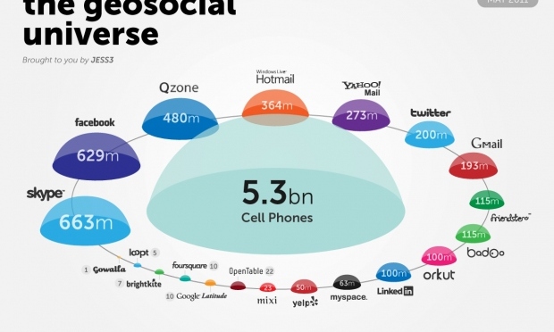
This was a peek at GeoSocial Universe. Have a look at this and let us know what you think!
More later